Powerful Hurricane Irene Continue damages and  increased death toll


on August 28th, becoming the first hurricane to make landfall in the state in more than one hundred years.

Hurricane Irene Storm-toppled trees, roiled surf and other effects left at least 10 people dead by August 27, 2011, Saturday night as Irene passed.

In Virginia, falling trees were blamed which killed a man in his 60s at his Chesterfield County house, a car passenger in Brunswick County, and a boy in a Newport News apartment.

A falling tree in Maryland killed one person in a Queen Anne's County house.

Yahoo news report dated August 28th, 2011, shows that currently about 1.5 million homes and businesses with no power in North Carolina and Virginia, which destroyed piers and killed at least seven people.  see below more detail by the state on a sea cost side: Also see above map for Hurricane Irene warning.

CONNECTICUT:

Irene predicted to make landfall Sunday between New Jersey and Cape Cod, in Massachusetts. Storm's track forecast through central parts of Connecticut.

Hurricane warning for coast:
Fairfield ordered a mandatory evacuation for shoreline residents as of noon Saturday, affecting 5,000 to 6,000 people.

Millstone nuclear power plant to be shut down if winds exceed 90 mph.

Last hurricane to hit was Bob in 1991.

Irene likely to cause prolonged power outages and flooding in low-lying areas along the shoreline.

President Barack Obama and governor declare state of emergency. National Guard mobilized.

DELAWARE

At least 36,000 homes and businesses without power.

Apparent tornado touchdown damages 15 structures near Lewes.

Indian River Inlet Bridge closed Saturday afternoon to all but emergency traffic.

Governor bans non-essential travel in the state.

Last hurricane to hit was Floyd in 1999.

FLORIDA

Surfer is killed Saturday off the central Florida coast after being tossed off his board by heavy waves caused by hurricane. Officials say a New Jersey tourist also died Saturday in rough surf.

MAINE

Irene predicted to reach northern New England Sunday night.

Governor declared an emergency.

Potential for flooding rains and gusty winds.

No evacuations planned.

Lobstermen began moving their fishing gear farther offshore to avoid damage amid expectations of 30-foot seas.

MARYLAND

More than 300,000 homes and businesses without power.

State police report an apparent tornado touchdown on the lower Eastern Shore; no injuries.

National Weather Service warns of flooding in parts of southern and central Maryland and the Eastern Shore.

Up to 8 inches of rain on lower Eastern Shore.

Maryland Transit Administration suspends service Saturday evening.

Last hurricane to hit was Floyd in 1999.

MASSACHUSETTS

Irene predicted to make landfall in southern New England on Sunday.

— Hurricane warnings issued for Martha's Vineyard. Hurricane watch in effect for the coastline to the mouth of the Merrimack River.

The governor and president declared a state of emergency. The governor deployed 500 National Guard troops, saying an additional 2,000 troops will be activated Saturday.

In Boston, the transit authority announced public transportation would be shut down Sunday because of the hurricane.

Mandatory evacuations have not been ordered.

Last hurricane to hit was Bob in 1991.

Red Cross is positioning emergency response vehicles, mobilizing disaster workers and preparing supplies.

Forecasts placed the storm's track through central Massachusetts.

NEW HAMPSHIRE

Forecasters predict Irene to reach northern New England Sunday night.

Heavy rain expected to start Saturday night. Potential for flooding rains and gusty winds.

No evacuations planned since path uncertain.

Governor directed state Emergency Operations Center to be opened.

The Red Cross plans to open four shelters.

Organizers of the annual Hampton Beach Talent Competition condensed the three-night schedule to two, telling competitors "it's one song for all the marbles."

NEW JERSEY

Forecasters predicted storm would pass over, or more likely, near New Jersey by midday Sunday.

Hurricane warning in effect for coastal and southern counties.

Mandatory evacuations ordered for nearly 1 million visitors and residents of Cape May County, coastal Atlantic County and Long Beach Island.

Governor and president declare state of emergency. State asks National Guard for additional communications equipment for its emergency responders.

Governor says more than 5,000 people already in shelters as hurricane threatens.

New Jersey Transit trains and buses to shut down Saturday.

Last hurricane to hit the state was remnants of Hurricane Floyd in 1999, which caused major flooding inland.

Atlantic City casinos shutting down for only the third time since gambling was legalized 33 years ago.

NEW YORK

Irene predicted to make landfall Sunday as a Category 1 storm between New Jersey and Cape Cod.

Hurricane watch and a flood watch issued for Long Island, New York City and suburban Rockland, Westchester and Putnam counties.

Mandatory evacuations ordered for New York City residents in low-lying coastal areas that are home to 370,000.

The governor declared a state of emergency and the state's Office of Emergency Management increased staffing in its underground bunker.

National Guard troops were heading to Rome, N.Y., where they could be ready to quickly get to New York City, Long Island or other shore areas, to transport supplies or provide search and rescue assistance.

New York City's public transit system, the nation's biggest, was shut down Saturday. The five main New York-area airports also closed.

Taxis in New York City switch from metered fares to zone fares.

NORTH CAROLINA

Hurricane warning for entire coast.

Governor and president declared emergency for the state. Eighteen eastern counties under some form of mandatory or voluntary evacuation.

Irene made landfall Saturday morning near Cape Lookout. Storm surge prediction of up to 11 feet in Pamlico Sound and up to 9 feet along Outer Banks.

Two storm-related deaths reported Saturday: One man killed in Nash County after a tree limb falls on him outside his home. A child died in Goldsboro after the car she was in crashed at an intersection where hurricane had knocked out power to traffic lights.

By early afternoon, more than 580,000 people were left without electricity.

The Neuse River pours over its banks and into the city of New Bern. Several dozen people had to be rescued from homes as up to 4 feet of water rushed in.

More than 60 shelters open in 26 counties.

1,300 prisoners evacuated from two coastal prisons.

Ferry service suspended until winds subside.

Last hurricane to hit was Isabel in 2003.

PENNSYLVANIA

Hurricane warnings in effect for Philadelphia and Delaware counties. Tropical storm warnings in effect for other parts of eastern Pennsylvania.

Governor declares state of emergency.

Tropical storms forecast as early as Saturday afternoon.

Half-foot or more of rain expected. In Philadelphia, where the mayor declared the city's first state of emergency since one triggered by racial tensions in 1986, the rain forecast follows an already single-month record of more than 13 inches.

Mass transit serving Philadelphia and its suburbs to halt at 12:30 a.m. Sunday.

Residents of low-lying areas in two Delaware County communities told to evacuate.

Last hurricane to hit was Floyd in 1999.

Flood and flash flood watches are in effect for parts of northeastern and central Pennsylvania through Sunday.

RHODE ISLAND

Irene predicted to make landfall Sunday. Six to 10 inches of rain expected to fall starting as early as Saturday night.

State of emergency declared.

Hurricane watch issued for much of the state. Tropical storm watch for portions of two inland counties.

Mandatory evacuations ordered for low-lying communities in Narragansett, South Kingstown and Bristol by 10 a.m. Sunday. Parts of Westerly are under evacuation orders by 6 p.m. Saturday.

Last hurricane to hit was Bob in 1991, which made landfall twice.

Residents warned to expect prolonged power outages and property damage.

Three-hundred National Guard troops on standby.

SOUTH CAROLINA

Irene was moving away from the state Saturday morning.

Tropical storm warnings remained in effect from Edisto Island to North Carolina state line.

No mandatory evacuations ordered.

Last hurricane to hit was Charley in 2004.

Downtown Charleston reported 49 mph wind gust just before noon Friday.

Beach erosion reported at high tide Friday evening on Edisto Island and Folly Beach.

About 5,000 customers without power from storms in Irene's outer bands.

VERMONT

Forecasters predict Irene to reach northern New England on Sunday night.

Heavy rain expected to start Saturday night. Potential for flooding rains and gusty winds.

No evacuations planned since path uncertain.

Parts of the state hard-hit by Memorial Day weekend flash flooding were bracing for another round.

VIRGINIA.

Hurricane watch for coast. Storm surge and rain were expected to cause flooding.

Governor declared emergency, says people who defy mandatory evacuation orders can be prosecuted.

Mandatory evacuations ordered for at least 11 localities, among them the Sandbridge section of Virginia Beach, a barrier island dotted with rentals, Accomack on the Eastern Shore, and for low-lying areas of Norfolk, Hampton and Portsmouth.

Three storm-related deaths reported: A person was killed when a tree fell on a car in Brunswick County. An 11-year-old Newport News boy dies when tree felled by storm crashes through apartment building. Another man died when a house was hit by a tree.

Apparent tornado heavily damages five homes in the Sandbridge area.

By Saturday afternoon, more than 600,000 customers in Virginia are without electricity.

Last hurricane to hit the state was Isabel in 2003.

Shelters opening in at least 14 counties and 12 cities, including Norfolk, Virginia Beach and Hampton.

The Navy ordered the Second Fleet out to sea to escape the storm.

Interstate 85 South near Petersburg closed because of trees toppled from Hurricane Irene.Hurricane watch for coast. Storm surge and rain were expected to cause flooding.

Governor declared emergency, says people who defy mandatory evacuation orders can be prosecuted.

Mandatory evacuations ordered for at least 11 localities, among them the Sandbridge section of Virginia Beach, a barrier island dotted with rentals, Accomack on the Eastern Shore, and for low-lying areas of Norfolk, Hampton and Portsmouth.

Three storm-related deaths reported: A person was killed when a tree fell on a car in Brunswick County. An 11-year-old Newport News boy dies when tree felled by storm crashes through apartment building. Another man died when a house was hit by a tree.

Apparent tornado heavily damages five homes in the Sandbridge area.

By Saturday afternoon, more than 600,000 customers in Virginia are without electricity.

Last hurricane to hit the state was Isabel in 2003.

Shelters opening in at least 14 counties and 12 cities, including Norfolk, Virginia Beach and Hampton.

The Navy ordered the Second Fleet out to sea to escape the storm.

Interstate 85 South near Petersburg closed because of trees toppled from Hurricane Irene.

WASHINGTON, D.C.

36,000 homes and businesses without power.

Homeless shelters are open around the clock.

City gives away sandbags to residents for a second day.

Approach of hurricane forced postponement of Sunday's dedication of Martin Luther King Jr. Memorial.

Last hurricane to hit was Hazel in 1954.

Hurricane Irene which is a North Atlantic tropical cyclone that inflicted extensive damage to Caribbean nations before making landfall in North Carolina, on the East Coast of the United States. The ninth named storm, the first hurricane and the first major hurricane of the 2011 season, Irene formed from a well-defined Atlantic tropical wave that showed signs of organization east of the Lesser Antilles. It developed atmospheric convection and a closed cyclonic circulation center, prompting the National Hurricane Center to initiate public advisories on the tropical cyclone late on August 20. Subsequent convective organization occurred as it passed the Leeward Islands, and by August 21, it moved very close to Saint Croix. The next day Irene made landfall at hurricane strength near Puerto Rico, where high winds and intermittent torrents caused significant property damage.

After crossing the Turks and Caicos Islands, the hurricane quickly strengthened into a Category 3 major hurricane while passing through The Bahamas, leaving behind a trail of extensive structural damage in its wake. Curving toward the north, Irene skirted past Florida with its outer bands producing tropical-storm-force winds. It made landfall over Eastern North Carolina's Outer Banks on the morning of August 27 Hurricane Irene made a second U.S. landfall at Little Egg Inlet in New Jersey on August 28th, becoming the first hurricane to make landfall in the state in more than one hundred years.

Hurricane Irene caused widespread destruction and at least eleven deaths; monetary losses to the Carribean could be as high as US$3.1 billion according to preliminary estimates.

Sources:Yahoo news, wikipedia, NOAA,

Reported by catch4all.com, Sandra Englund, August 28, 2011


Powerful Hurricane Irene caused
One Fatality in North Carolina, August 26, 2011
Present Obama urges precaution and  Federal Support

Hurricane Irene: Atlantic hurricane that inflicted extensive damage to Caribbean nations before making landfall in North Carolina, United States. It is currently threatening the Mid-Atlantic and New England regions of the United States as well as eastern Canada. Meanwhile, Yahoo News, dated, August 27, 2011, AP News reported, Carolina coast early Saturday as the storm began its potentially catastrophic run up the Eastern Seaboard. More than 2 million people were told to move to safer places, and New York City ordered the nation's biggest subway system shut down for the first time because of a natural disaster.

The National Hurricane Center in Miami said Irene's maximum sustained winds were around 85 mph on Saturday morning, down from about 100 mph a day earlier. But they warned the hurricane would remain a large and powerful one throughout the day as it trekked toward the mid-Atlantic.

"The hazards are still the same," NHC hurricane specialist Mike Brennan said. "The emphasis for this storm is on its size and duration, not necessarily how strong the strongest winds are."

Hurricane-force winds first arrived near Jacksonville, N.C., around 6:15 a.m. A little more than an hour later, the storm's center passed near the southern tip of North Carolina's Outer Banks. You can see more detail and differences  of wind pressure via NOAA's Hurricane Irene Status Snap Shot for MCAS (Marine Corps Air Station) NEW RIVER, NC,  United States:

On August 25, Governor Bev Perdue declared a state of emergency for the state of North Carolina. Governor Perdue also asked President Barack Obama to declare a federal emergency. 

Also on August 25, Seymour Johnson Air Force Base planned to move jets to Barksdale Air Force Base in Louisiana. As well, Marine Corps Air Station Cherry Point and Marine Corps Air Station New River both evacuated their aircraft to an unknown location.

Starting at 1 p.m. on August 25, a mandatory evacuation was issued for all residents and visitors to Carteret County.

The set up of four shelters at schools was scheduled in Carteret County. Residents at the Bogue Banks were urged to commence evacuations by 6 a.m. August 26.

Tourists in Currituck County were told to move inland.  A mandatory evacuation for residents of Dare County was issued effective 8 a.m.  August 26. A curfew for 8 p.m. was in effect for those who remained behind. Pamlico Community College located in Grantsboro was opened on August 26 to shelter from the storm. Shelters were open in Nash, Wilson, Halifax, Northampton, and Onslow Counties. Progress Energy announced on August 26 it would have 800 more line workers and 250 tree cutters ready after Hurricane Irene. As low-level confluence associated with the outer bands moved over the coast, a tornado watch was issued from 40 miles (64 km) north-northeast of Cape Hatteras to 15 miles (24 km) southwest of Wilmington.

Just after daybreak in Nags Head on the Outer Banks, about 200 miles northeast of Jacksonville, winds whipped heavy rain across the resort town. Tall waves covered what had been the beach, and the surf pushed as high as the backs of some of the houses and hotels fronting the strand. Lights flickered in one hotel, but the power was still on.

See more detail via youtube: CNN News:

According to meteorologists, the greatest risk from this storm is not its wind speed (although wind is a danger), but its ability to drive unusually high and potentially deadly coastal flooding, due to the storm's extremely wide area of "ocean-push". As well, because the storm is slow-moving, its impact is magnified over time in the areas it passes over. Irene is a very large storm; hurricane force winds extend up to 90 miles (150 km) from the center of Irene, and tropical storm force winds extend 260 miles on either side (415 km) from the center, making the storm system an unusual 580 miles across, amplifying its effects on storm surge, rainfall and sustained high wind duration.

CNN reported that About 550,000 power customers were without electricity in North Carolina and Virginia because of the storm Friday afternoon, according to state and utility reports.

President Obama urges Americans in the projected path of Hurricane Irene to take precautions  and provides ongoing federal preparations. see below for more detail via Whitehouse Report: and Youtube

Statement by the President on Preparations for Hurricane Irene

Fisher House at Blue Heron Farm, Martha's Vineyard, Massachusetts

11:28 A.M. EDT

THE PRESIDENT:  Good morning, everybody.  I want to say a few words about Hurricane Irene, urge Americans to take it seriously, and provide an overview of our ongoing federal preparations for what's likely to be an extremely dangerous and costly storm.

I’ve just convened a conference call with senior members of my emergency response team and directed them to make sure that we are bringing all federal resources to bear and deploying them properly to cope not only with the storm but also its aftermath. I’ve also spoken this morning with governors and mayors of major metropolitan areas along the Eastern Seaboard to let them know that this administration is in full support of their efforts to prepare for this storm and stands ready to fully support their response efforts.  And we will continue to stay in close contact with them.

I cannot stress this highly enough:  If you are in the projected path of this hurricane, you have to take precautions now.  Don’t wait.  Don’t delay.  We all hope for the best, but we have to be prepared for the worst.  All of us have to take this storm seriously.  You need to listen to your state and local officials, and if you are given an evacuation order, please follow it.  Just to underscore this point:  We ordered an aircraft carrier group out to sea to avoid this storm yesterday. So if you’re in the way of this hurricane, you should be preparing now.

If you aren’t sure how to prepare your families or your home or your business for a hurricane or any other emergency, then you can visit Ready.gov -- that's Ready.gov -- or Listo.gov.  That's Listo.gov.

Now, since last weekend, FEMA has been deploying its Incident Management Assistance Teams to staging areas in communities up and down the coast.  FEMA has millions of liters of water, millions of meals, and tens of thousands of cots and blankets, along with other supplies, pre-positioned along the Eastern Seaboard.  And the American Red Cross has already begun preparing shelters in North Carolina and other states.

These resources are all being coordinated with our state and local partners, and they stand ready to be deployed as necessary. But, again, if you are instructed to evacuate, please do so.  It's going to take time for first responders to begin rescue operations and to get the resources we've pre-positioned to people in need.  So the more you can do to be prepared now -- making a plan, make a supply kit, know your evacuation route, follow instructions of your local officials -- the quicker we can focus our resources after the storm on those who need help the most.

To sum up, all indications point to this being a historic hurricane.  Although we can’t predict with perfect certainty the impact of Irene over the next few days, the federal government has spent the better part of last week working closely with officials in communities that could be affected by this storm to see to it that we are prepared.  So now is the time for residents of these communities -- in the hours that remain -- to do the same.  And FEMA and Craig Fugate, the director of FEMA, will be keeping people closely posted in the next 24, 48 hours.

Thank you very much.

END 11:31 A.M. EDT

CNN also reported that President Barack Obama continued to closely monitor the storm, according to White House officials. He toured FEMA's operations center Saturday morning. Meanwhile, defense officials told 6,500 service members to prepare to deploy to storm-ravaged regions should state officials need them.

The Red Cross sheltered 13,000 people in 150 shelters Friday night, President Gail McGovern said. More than two-third's of the non-profit's emergency response vehicles had deployed to the East Coast, she said..

The first death from the storm was reported in Nash County, N.C., outside Raleigh, where emergency officials said a man was crushed by a large limb that blew off a tree. So far Death toll occurred  Puerto Rico 1, Dominican Republic 3 dead and 7 missing, Haiti, 2 dead, United States 3 dead and 1 is missing  which total 8 fatalities caused by Hurricane Irene. You may select by the state and find out your Severity via National Weather Service: Internet Weather Source: NOAA .

Sources:yahoo news, wikipedia, NOAA, and CNN, Boston.com and AP

Reported by catch4all.com, Sandra Englund, August 27, 2011

See more detail  via NOAA


National Weather Service: National Hurricane Center
Hurricane Irene Warning August 25, 2011


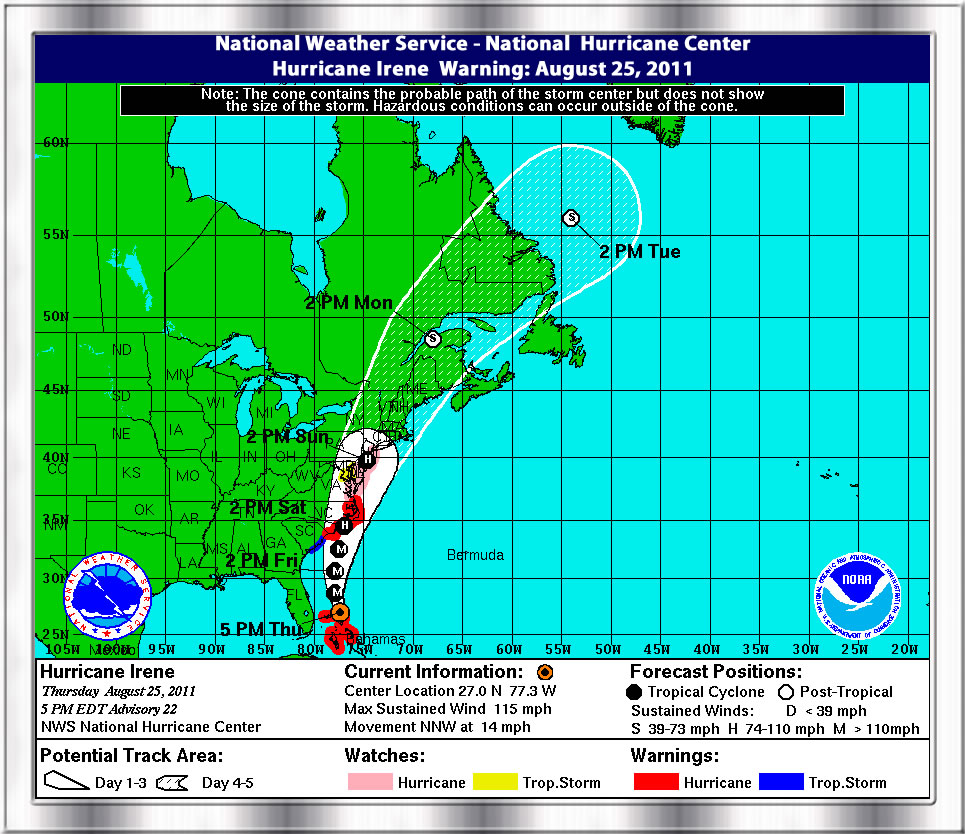
According to Reuters, dated August 25, 2011, NEW YORK (Reuters) - New York City prepared to evacuate coastal areas and rescue stranded New Yorkers with a fleet of police boats in case the city gets socked by Hurricane Irene this weekend.

"We hope for the best but we prepare for the worst and that's why I think this city is ready for this weekend," Mayor Michael Bloomberg told reporters on Thursday while outlining the city's hurricane preparations.

Irene, now a powerful Category 3 hurricane battering the Bahamas, was projected to move up the East Coast, possibly hitting New York late Saturday or Sunday.

Forecasters said Irene would likely weaken as it moved north and could hit Long Island to the east of New York City as a Category 2 storm.

"At this point the forecast does not indicate the storm will hit New York City with that strength but we certainly will see its effects here including tropical storm like conditions such as heavy rains and winds of 60 mph or more," Bloomberg said.

Bloomberg, who was politically damaged by an insufficient city response to a blizzard in December, said the city had activated a command center at the Office of Emergency Management and that all the city's emergency response agencies had additional staff at the ready.

Police were positioning 50 launches at station houses in low-lying areas and the police department's Special Operations Division had another 33 boats plus several helicopters ready to rescue New Yorkers if needed, Bloomberg said.

Bloomberg was prepared to order mandatory evacuations from low-lying areas if needed, but "only in the worst of circumstances." He said the city might need decide on evacuations some time on Friday, depending on the speed and track of the storm.

City hospitals have tested emergency generators and filled their fuel tanks while ensuring they have adequate medical supplies in case deliveries were cut off, Bloomberg said.

Heavy equipment was being moved to high ground and catch basins for storm water were being cleared of debris ahead of time to prevent flooding, Bloomberg said.

The city was doubling its outreach for homeless people, to be ready to move them quickly into shelters, and a city program for homebound elderly would delivery extra meals, the mayor said.

----------------------

Hurricane Irene is an Atlantic hurricane that inflicted extensive damage to Caribbean nations before making landfall in North Carolina, United States. It is currently threatening the Mid-Atlantic and New England regions of the United States as well as eastern Canada.

The ninth named storm, first hurricane, and first major hurricane of the 2011 season, Irene developed from a well-defined Atlantic tropical wave, which showed signs of tropical development east of the Lesser Antilles.

It developed atmospheric convection and a closed cyclonic circulation center, prompting the National Hurricane Center to initiate public advisories on the tropical cyclone late on August 20.

Subsequent convective organization occurred as it passed the Leeward Islands, and by August 21 it moved very close to Saint Croix. The next day Irene made landfall near Puerto Rico, where high winds and intermittent torrents caused extensive property damage. The hurricane strengthened as it passed through southeastern Bahamas, becoming a major hurricane on August 24.  However, on August 25, 2011, New York declared emergency evacuation which had to shutdown of all city subways and buses as the Hurricane Irene category takes aim at the city could change to category 4.

The massive storm, a Category 3 as of Thursday night packing sustained winds of 115 mph, was on target for a direct hit in the New York area on Sunday afternoon, bringing with it torrential rain, massive storm surges, devastating winds and the potential for severe flooding.

DNAinfo.com news shows that Mayor Michael Bloomberg said in a hastily-called press conference at City Hall Thursday evening "What we have to do is assume the worst, prepare for that, and hope for the best,". Read more: via DNAinfo.com

See more detail via youtube which describes that Category 3 hurricane could reach category 4:

At 1500Z the center of hurricane Irene was located near latitude 30.7 North... Longgitude 77.3 west with maximum sustained winds near 90 KTS... 105 MPH...165 KM/H.  You can see the maxmum wind speed (intensity) Probabilities in below via NOAA's script per each Hurricane Category:

You will be able to see the each locations for the wind speed probabilities as allocated in below:

See more detail  via NOAA

Sources:

USGS

NOAA

Wikipedia

Yahoo News

DNAinfo.com


Reported by catch4all.com, Sandra Englund, August 25, 2011

Click to see 787 Dreamliner

787 DREAMLINER Accomplishes Major Mileston : POWER ON


The Biggest
in the World

Boeing Airplane 747-8

You Will Never Forget Dreamliner 787

The Boeing Company Products

Boeing Outlook 2008 to 2027

Global Tanker Home Page


FUTURE OF FLIGHT


Catch4all.com is proud to provide positive websites for the communities and for
the positive viewers from all over the world.....

Positive Viewers' Menu
2003 to 2010


Thank you for visiting Catch4all.com. Please be sure bookmark our site.
Since 1999 ©Catch4all.com. All rights reserved.